


AvNav EFB

AvNav EFB leírása
A legfejlettebb Flight Planning and Navigation App Pilóták Androidon. AvNav van pilóták számára, akik élvezik a helyi és sífutó repülő különböző terep és az időjárás (néha IFR feltétel). Repülő az Egyesült Államokban csak.
Főbb jellemzők:
& Bull;
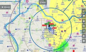
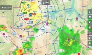
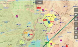
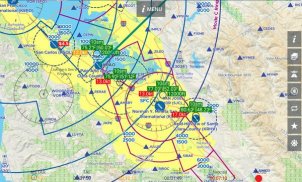
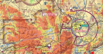
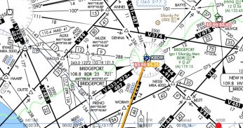
varrott zökkenőmentes VFR szekcionált, TAC és IFR grafikonok e az észak-fel vagy nyomon módban, a diagramok mindig a kiváló minőség és a gyors megjelenítés
& Bull;
vektoros térkép réteg nem mutatja a fizikai jellemzők, mint a folyók, utak, és a tavak mellett légiforgalmi funkciók, mint például a levegő-terek, a repülőterek és az időjárás jelző. Még részletek, mint a guruló utak és pályák vannak ágyazva a térképen.
& Bull;
Victor Airways, az FP-k és a csillagok, a repülési terv csak Android App erre. AvNav beilleszti minden közbenső útpontok a megközelítés, és függőleges irányítással az útvonal mentén.
& Bull;
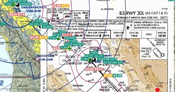
földrajzi hivatkozással megközelítés lemezek és repülőtér diagramok lásd a géped Airport diagramok és Megközelítés lemezek. Úgy is lehet tekinteni, mint overlay térkép oldalon.
& Bull;
FBO Információs és üzemanyagárak (naponta frissül) szerepelnek az App. Üzemanyag árak is megjelennek a térképen oldalon is. Kereshetünk az alacsonyabb árú üzemanyag és FBOs a levegőben.
& Bull;
Terep: lásd terep felett a magasság, piros és tudja, hogy képes lesz világos terep előtted. Új verzió 4 mi egyedülálló, hardveresen gyorsított domborzatárnyékolásra.
& Bull;
Az Air , AvNav mutatja a GPS pozíció a listákon, és kap frissített információkat
ADS-B vevő az Ön által választott megjelenítéséhez forgalmi és időjárási térkép oldalon.
& Bull;
zavartalan időjárás ikonok a térképen oldalon lásd METAR paraméterek, mint a Sky állapotban, mennyezeti, hőmérséklet térkép oldalon is.
& Bull;
Gyors letöltések keresztül Amazon AWS - , amíg nem kell semmilyen letöltés eltérő App az induláshoz, a pilótafülke offline felhasználható diagramok szükséges és rendelkezésre álló keresztül AWS. A letöltések gyorsak, és letöltheti több grafikonok egyidejűleg. Akkor továbbra is használja az alkalmazást, míg letöltés folyamatban van.
& Bull;
Előnyös utak , hogy milyen más pilóták a bejelentés a származási és rendeltetési hely.
& Bull;
Mindig gumi-sávos egyszerűen húzza az útvonal megtervezéséhez körül SUAs, TFRs, a rossz időjárási és terepviszonyok.
& Bull;
Fúvós magasba optimalizált repülési tervek és a magasság optimalizáló nem repülnek nélkül szél adatok - nem mindegy!
& Bull;
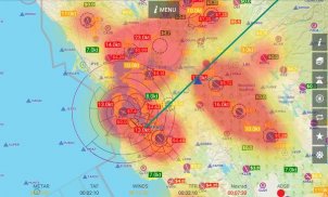
A statikus és animált / loop NEXRAD overlay a térképen oldal együtt Műholdképek és AIRMET / SIGMET / PIREPs.
& Bull;
TFRs, A, B, C légterek és aktív vagy várakozó SUA és MOA átfedések a térképen oldalon
& Bull;
Duat benyújtása és Briefing - Akkor nyújthat FAA repülési terv és kap időjárás tájékoztatást az App magát. A legtöbb információ automatikusan átmásolja aktív repülési csökkentve ezáltal bármilyen szükséges gépelés.
Pricing: 30 napos ingyenes próba, majd 74,95 $ / év, illetve 7,95 $ / hó - tartalmazza az üzemanyagok ára, a terep és földrajzi referenciákkal megközelítésre lemezek és repülőtéri diagramok.
AvNav EFB - 5.2.5-prod verzió
(30-05-2024)
AvNav EFB - APK információ
APK verzió: 5.2.5-prodCsomag: us.avnav.efbAvNav EFB legújabb verziója
Egyéb változatok


Appok ebben a kategóriában


